
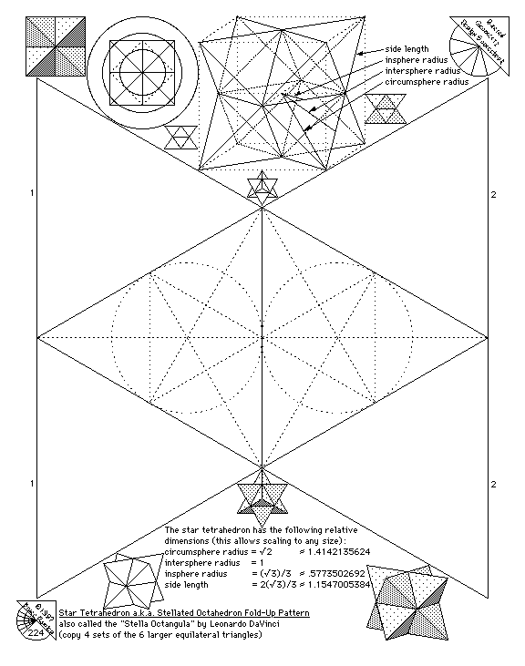
Sacred Geometry Design Sourcebook - sample - (page 224) Star Tetrahedron Fold-up Pattern
This pattern requires 4 copies to make a finished model.
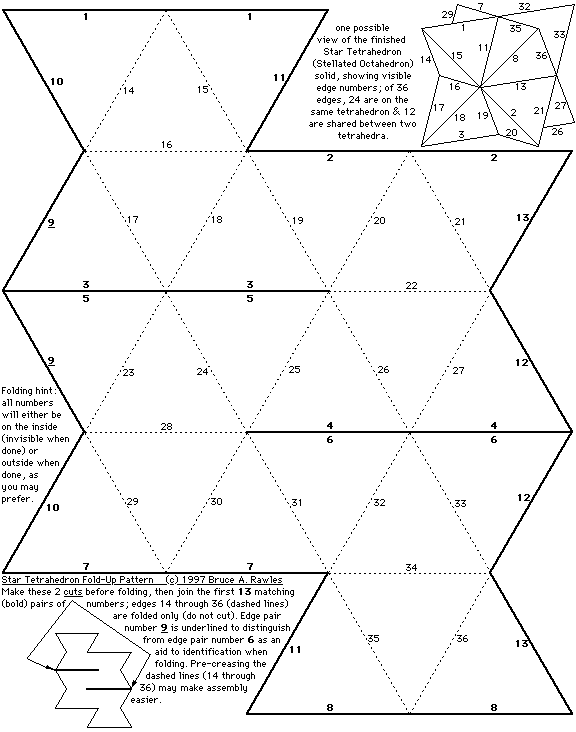
Sacred Geometry Design Sourcebook - bonus - Alternate Star Tetrahedron Fold-up Pattern
Here's another (smaller) fold-up pattern for a Star Tetrahedron. This pattern requires only 1 copy to make a finished model, but requires 2 additional cuts. It may be easier for some to put together, and has less taping and cutting than the first model.
Hint: Using one half of a slender pair of scissors carefully slid through the gaps in the almost-finished solid to apply the last 2 or 3 pieces of tape may make the final steps easier... and it DOES get easier with practice!!! :-)
The star tetrahedron is related to the merkaba shape, according to Drunvalo Melchizedek, Gregg Braden, and many others. This is also the same shape that Richard Hoagland and other researchers have found to be related to points of volcanic activity on Io (a moon of Jupiter), Mars, and many interesting points on Earth at approximately 19.5 degrees North or South Latitude (more precisely 19 degrees, 28 minutes, 16.39428 seconds) - here are a few:
- Mauna Loa, Hawaii (19 degrees 28 minutes N, 155 degrees 37 minutes W)
- Mexico City, Mexico (19 degrees 23 minutes N, 99 degrees 10 minutes W)
- Dzibalchen, (Yucatan), Mexico (19 degrees 28 minutes N, 89 degrees 46 minutes W)
- Georgetown, Grand Cayman Island (19 degrees 18 minutes N, 81 degrees 26 minutes W)
- Mount Emi Koussi, Chad, Africa (19 degrees 47 minutes N, 18 degrees 34 minutes E)
- Mount Kalsubai, (near Bombay), India (19 degrees 33 minutes N, 73 degrees 43 minutes E)
- Mountain near Xiangkhoang, Laos (19 degrees 17 minutes N, 103 degrees 17 minutes E)
- Mountain near Potosi, Bolivia (19 degrees 13 minutes S, 66 degrees 22 minutes W)
- Yasur Volcano, Tanna Island, Vanuatu (South Pacific Ocean) (19 degrees 31 minutes S, 169 degrees 25 minutes E)
- Mount Samuel, Northwest Territory, Australia (19 degrees 13 minutes S, 134 degrees 8 minutes E)
- Gweru, Zimbabwe, Africa (19 degrees 31 minutes S, 29 degrees 49 minutes E)
W or E refers to West or East Longitude, N or S refers to North or South Latitude, approximations, interpolated visually from the atlas. (reference : National Geographic Atlas of the World, revised 6th edition, 1992)
No comments:
Post a Comment
the mikiverse loves free speech and wholeheartedley accepts, that someone who is diametrically opposed to my views is free to promulgate those thoughts...However, misogyny, racism, intolerance etc will see that comment deleted.
These abstract considerations will be solely, and exclusively determined by the mikiverse, so play hard, but, nice.